Thursday, 14 July 2016

A Cairngorms crossing at work

Incredible 4am morning skies above the Cairngorms
I love my job as a Mountain Leader, but every now and then you have a week at work that is different (in a good way) from the 'norm'.  Last week was a example of that.  Having worked for Rough Edge Adventure Logistics for a while, we made our staff dreams come true and took a Gold DofE expedition to the Cairngorm National Park in Scotland.  
Walking up the valley from Spittal of Glenshee ahead of the teams
This was going to be an exciting, challenging and fun week of work.  The planned route crossed the entire national park from Bridge of Cally (South of Glenshee) to Aviemore.  With days up to 28km long, in remote country where the only escape is via mountain rescue or a 12km walk in some areas the teams would need to be strong and competent.  On the flip side it would be a truly adventurous and wild journey harking back to the days when fewer people walked in the UK hills.  As one participant described excitedly to her parents on the phone, 'we only saw eight other people excluding our team and instructors'.
First night in the instructor wild camp in the Cairngorms Photo by Dan Lane
As the route was so remote this meant that our team of instructors would be wild camping and crossing the Cairngorms for three days aswell (Day 1 was more easily supervised from walking up from the road).
Walking past the student's wild camp at 5am one morning to begin the day's work
In addition to being physically fit for the route we gave the teams a full day of training before they set off, to refresh their skills and ensure we were happy for them to head off on their qualifying expedition.  (It can sometimes be a long time between training, practice and qualifying trips for students, and in the meantime most of them have been focused on school exams).  For the Scottish environment this also included:
  • River crossings
  • Ticks - a reminder on what they are, how to avoid them and how to remove them
  • Emergency procedures
  • Registering on the 999 emergency text service
  • Fitness
  • Navigation refresher
  • Strict kit checks
  • And much more...
Checking out (rather dry) river crossings while waiting to meet the groups as they walk down the valley
Remote supervision during this week not only meant checking the groups were doing well, but also meant checking out parts of the route that crossed footbridges and fords just ahead of the teams to ensure they were passable or whether we would need to be present with the groups as they crossed them.  Luckily the weather forecast was reasonable and none of the watercourses were in spate.  After the late winter storms several websites were used to ensure the routes hadn't washed away including the DofE area one (these are quite useful for planning personal trips too).
Can you spot the group in the distance?
Below are some photos of the week, it was a huge success with all three teams completing the entire expedition with nothing more than sore feet and weary muscles.  I hope we at Rough Edge have sown the seed of many future expeditions to come, both for the students and as a company.  Congratulations to the groups and here's to many more adventures in the future.

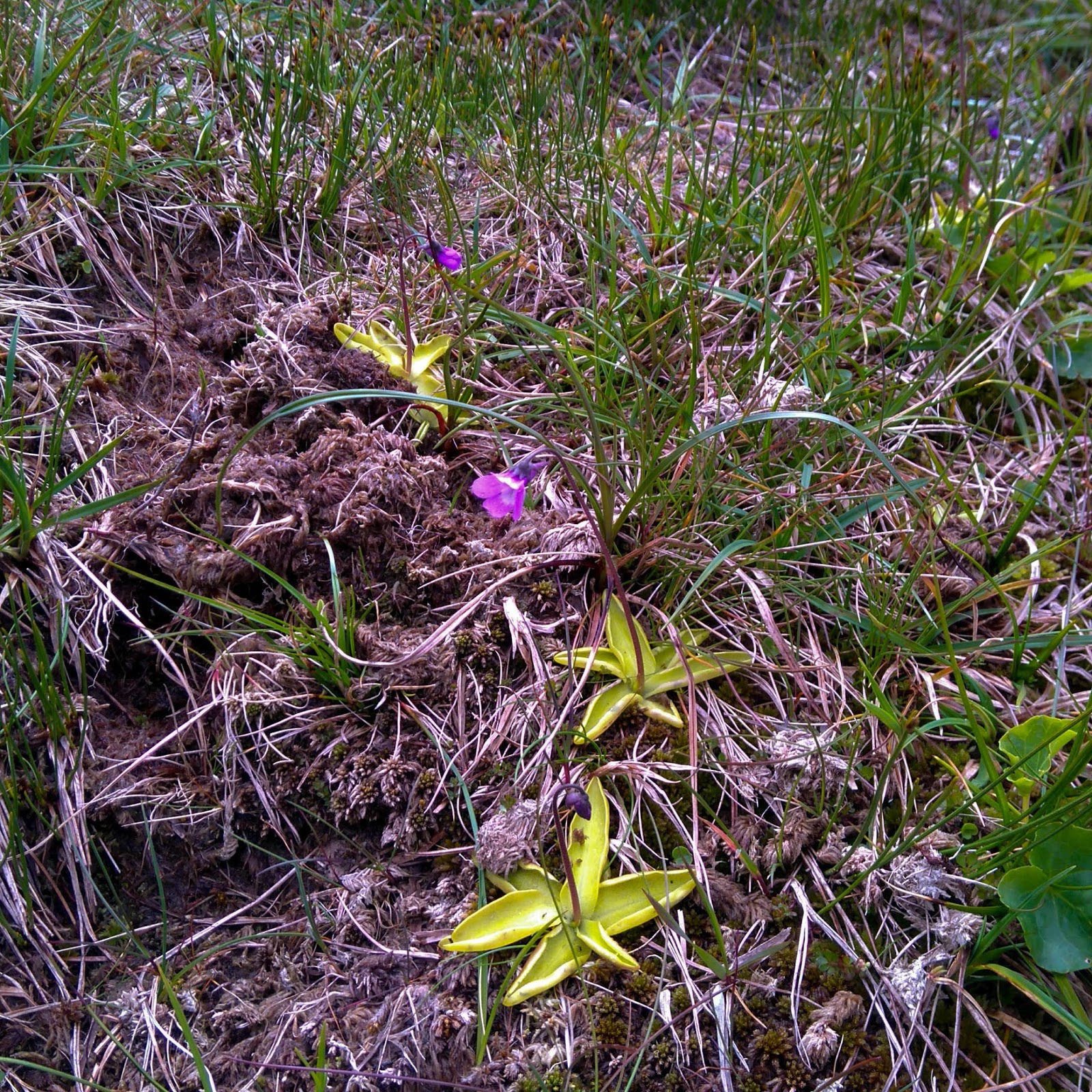
Butterwort in flower, one of many wild flowers we saw
Munro bagging and checking phone signal in the area
Looking down the Lairig Ghru on the last day
A beautiful morning munro run to fire off a few text messages (4G on the summit!)


Preparing breakfast while waiting for the teams to walk past in the distance
4am at the instructor wild camp - the views were worth unzipping the tent door for

Gareth and Ed striding along the valley on Day 3
Ed and I crossing what was our largest river of the trip (luckily it didn't rain much during the week or this would have been a lot more hands on) Photo by Gareth

The perks of staying near a bothy = a nice fire

Saturday, 25 June 2016

V3K Ultra race report (Vegan Welsh 3000ers) - My first ultra race finished

Last Saturday 18th June was the annual V3K ultra race, the first race of the year in the UK sky running calendar, and I had, rather stupidly, booked myself a place.  I say stupidly because the last running race I attempted I didn’t finish, the one before that I finished but didn’t get my food and water intake right, and the race before that I didn’t finish either!  Add to that, that I had only just returned from a long expedition and had only done a couple of runs in the last 6 weeks and you’ll understand why it was becoming a ridiculous idea.  But then there was nothing to lose.  54km of running over my local mountains, with 4000m ascent.
Looking fresh at the V3K ultra start
3:45am alarm clocks ring, banana oaty pancakes and coffee for breakfast (kindly cooked by Jim who got up at 3:30).  Dressed in running kit, double check compulsory kit, check 4 safety pins holding race number onto shorts, check phone and watch charged, check heart rate monitor is on and working, check food and water are all in the correct pockets, put midge spray on, check check check and check.

4:20am driving to the race start and find ourselves behind the coaches of runners, at least I won’t be late then.
The race start, full of lean sky runners, marshalls and midges!
5:00am race begins with a fast ascent of the South Ridge of Snowdon, leaving the midges behind.  Initially starting up the Watkin path, you soon split off to the left as you would to climb Yr Aran.  I raced up, alternating between jogging and power walking, trying hard to focus on breathing steadily and keeping a pace of 800-1000m ascent per hour.  My initial goal was to get to Snowdon’s summit within 90 minutes of leaving the road, having eaten some food; I got there in 78 having eaten 1 and a half bars.  Feeling great I hurried past the summit ‘rush hour’ as hundreds of walkers plodded up, and was soon joining other runners along the way to Carnedd Ugain.  Peace again.
Balancing along the Crib Goch ridge in the fog
Crib Goch, the ‘knife edge ridge’ was covered in low fog, enabling you to see around 100m infront and no more.  Being local definitely helped here as I knew roughly where some of the faster more runable sections are, in addition to feeling confident travelling purposefully along the ridge.  The first section of Crib Y Ddysgl was incredible slippy and greasy.  Passing a few groups heading in the opposite direction, in addition to some slower runners I made great time and felt confident in my abilities, so far so good.  But the worst was yet to come, the screes down to Nant Peris.
Running along Crib Goch is always fun, even in the fog Photo by Andy Milton
Punched the first set of holes in my checkpoint card and followed the occasional flag down to the very end of the North Ridge of Crib Goch before disengaging my brain and just going for it down the screes.  Descending technical or uneven terrain is my ultimate weakness and I knew after last year’s attempt at the Glencoe Skyline, that I just had to run it to avoid being timed out.  Imagining skis on my feet I kept a high cadence, ran and survived.  Losing the ‘path’ a bit in Cwm Glas cost me a couple of minutes, but soon I was back on track and out of the fog.  Legged it down the road at 10km/hr and was soon greeted by cheering at the first aid station.

7:47am arrived at the aid station, I couldn’t believe I was there around an hour before my estimated time, this worried me a little, but also gave me a much needed boost (maybe I could actually finish the race after all I thought).  Filled water bottle with half coke half water mix, ate food, packed another bar, packed jam sandwiches, picked up trail running poles.

7:52am left aid station and started the long 800m ascent to Elidir Fawr.  Despite being a long ascent, time seemed to pass quickly, and by now my feet and shoes were soaked through having chosen bog and marsh over the long way around.  More food and water consumed.  The fog remained thick and I only saw a few other runners.  2nd checkpoint stamped.
Energy levels were still high as I powered up Y Garn into more thick fog
How pleasant it was to be descending quickly, my legs still felt strong and I would be up Y Garn in no time at this rate.  The next peak was over, more descending, a cup of tea from the lovely marshalls at Llyn Y Cwn, and then a 300m climb to Glyder Fawr up more scree.  This wasn’t too bad either, however I was very glad that I knew the area so well, as the course markings were rather sporadic at times and I would have had to navigate properly across the Glyderau.  An occasional check of my phone GPS sufficed for peace of mind.

Glyder Fach soon arrived as I skipped across the uneven rocky terrain, but no sign of the checkpoint stamp or marshall.  Descending downwards we spotted them, some misinformation as to their true location was given beforehand.  Phew, I picked up my 3rd stamp and continued on, legs firing, to the Miner’s Track.  Traversing to the Tryfan wall, and the hills began to get busier again.  The summit was littered in hill walkers and runners, and soon the descent straight down the gully started.  This was the only section of the course I had never done before, and I couldn’t believe how direct and easy to follow it was.  After a short section of bum sliding and down stepping, man made steps arrived and I galloped down them, overtaking several other runners, yes… overtaking while running downhill.  This seemed preposterous to me, the runner who can’t run down hills.
Descending quickly down the steps from Tryfan Photo by Andy Milton
12:09 Arriving into Glan Dena aid station, I felt tired for the first time, and knew I was as I could only manage 8km/hr rather than 9km/hr along the road.  The Carneddau would be difficult.  The good news was that this eating and drinking while running thing was actually working, I couldn’t believe the difference it made.  Over the Glyderau I had consumed 1litre of liquid, 2 jam sandwiches and a bar.  Sitting down inside the bunkhouse I ate some vegan lemon drizzle cake - actually quite nice (I’m not a vegan), topped up bottles, put more jam sandwiches in my bag and dropped off my 2nd extra warm top.

12:19 Ran out of Glan Dena towards Pen Y Ole Wen, the last big climb of the day.  Having taken each section of the day in small stages so far I only thought about getting to the top of this climb, forgetting the other 25km running left to do.  Impressed that I could still ascent at 800-850m/hr I still felt positive, but my legs were tiring.  This showed as I could no longer bound from rock to rock across the Carneddau, everything began to ache.  At times the fog cleared and you could see for miles, then it would return with a vengenace, requiring the occasional GPS check.  Although familiar with this section of the course, the GPS could tell me exactly how much further I had until the next peak.

Soon the first out and back to Yr Elen arrived, flagging, a couple of people who had overtaken me earlier passed me by, fleeting words of encouragement were passed, I was still smiling!  Carnedd Llewelyn came and went, and I tried my hardest to get those sprightly legs to return to me.  Come on legs…  They didn’t, patient jogging over the rocks took over, until the grassy tracks towards the northern peaks replaced them.  Patient jogging continued, a forced injection of speed running did nothing to invigorate them, so I was damned to forever plod on at this pace of 6-7km/hr.  Secretly I wished to do the 3000ers top to top in 8-12hrs, and finish the race in under 12hrs.  Ambitious.
Nearing the end of the Carneddau and the uphill, this track went on forever
15:43 Relief poured over me upon reaching Foel Fras, the last top in 9hrs 25 top to top.  No more big climbs left, and the only way back was on foot, I had, effectively finished, as I now had to get down unless injured.
Jogging slowly towards the sea and the finish line at Hendre Hall, all downhill from here. Photo by Andy Milton
Returning to Hendre Hall, Tal Y Bont, from the Carneddau is beautiful.  Whatsmore, the fog began to part and I could see the sea in addition to all of the peaks previously summitted earlier today.  It was stunning, but I just couldn’t stop to take photographs.  My legs were fading fast, and all I could concentrate on was getting down, not tripping over, and trying not to cry with excitement!
Running into the finish line at Hendre Hall
17:18 Killer steep downhill tarmac to the finishing line, and it was over.  Slate medal awarded, vegan food consumed, discovered I couldn’t walk up anymore stairs (glad I live in a Bungalow!), more food on the way home - bacon cheeseburger (not very vegan!), massage, stretching, hot shower, smiles, exhaustion and sleep.

I can’t describe how thrilled I am to have finally finished an ultra race.  After another year of trail running, trying to work on my descending, and having the guts to enter another ‘crazy’ race I think it all paid off.  To summarise, all I can say is, it was a great day in the hills, and eating and drinking while running definitely helps.  Thanks Jim.
At the finish having just received my medal.

Thursday, 23 June 2016

Logan Expedition Blog 2, The ‘Logan Effect’ Base Camp - Football Field Camp 3

Before the journal commences here is a quick weigh in of all of my kit that was flown onto the glacier:
  • Me plus ski boots, camera and lots of ski clothing: 149lbs
  • Small food bag: 13lbs
  • Big food bag: 24lbs
  • Rucksack: 61lbs
  • plus pulk and share of tent and fuel (100g per day per person?): lots more pounds

Total: 117lbs personal kit and food, plus group kit and myself
Skinning up to Camp 1 from Logan Basecamp
Monday 9th May 2016 - Rest day (bad weather) at Logan King’s Trench Basecamp
Not much happened today, knowing the weather was going to be bad we had already planned to take the day off.  We spent the bulk of the day eating food, reading, sleeping, chatting and occasionally digging the tents out.  The weather today wasn’t awful, however four days of high pressure were forecast from tomorrow.
Setting off to move up to Camp 1
Tuesday 10th May - Basecamp - Camp 1
Today our daily routine of waking up at 7am (to bright glorious sunshine) and leaving by 10am began.  Rarely on the trip would we manage or need to make this less than 3 hours.

My feet got so warm in I nearly got blisters photo by Cathy O'Dowd
The long haul up to camp one began, and I was feeling really strong, slowly acclimatising and enjoying the views and weather.  We needed to break trail today, however due to the high winds it was only a couple of inches deep, and the crevassed corner posed no problems.  To be on the safer side, and for practice as a team we all moved roped up.

Arriving in time for lunch we made camp, dried out boot liners and sleeping bags and had a good rest before skiing down to collect our cache from 2 days ago.  For dinner I forced down 2 Mountain House meals (500-550cal a pop), soup, hot chocolate and chocolate.  Way too much food, and I paid for this by spending the night trying not to be sick, digesting it all.  This was my first warning sign that maybe 750g of food a night was 250 too much.

741m ascent, 10km, 4.5hrs
The start of the route from Camp 1 to King Col Camp 2, the steepest section being the ramp on the LHS
Wednesday 11th May: Camp 1 - King Col Camp 2 - Camp 1
Feeling grumpy for the first time this trip, and my stomach still feeling full I survived the morning on coffee and one ginger nut biscuit.  This was going to be a very long day.  Under the baking hot sun we hauled a load to cache at Camp 2, King Col Camp.

Tent city at King Col
Initially the terrain steadily rose upwards, we zigzagged our way up one steeper slope (no need for kick turns though) and soon saw our destination for the day.  This is when the ‘Logan Effect’ really kicked in.  The glaciers are so huge that perspective is challenging.  A small rise or depression can seem 10minutes away, but actually take an hour or more.  The last section seemed to go on for ever.  My mind drifted between thinking of nothing, pondering the vegetable patch at home, marching on, looking at my watch to see how high we were and trying to will my stomach into digesting it’s contents.  By this stage I couldn’t go more than 2km/hr and had to ask my rope team to slow down the pace, something I haven’t asked in years!

We arrived at the col to ‘tent city’ and lots of whooping Canadians as they skied down the powder fields from a saddle on King Peak.  No one had passed through the ice field yet this season and so most of the groups there had gone for a quick recce and acclimatisation day to check where to put the best route in.  As the technical crux of the route, and highly crevassed, this was a key step to the summit.

Thighs burnt as we skied back to Camp 1, and I arrived, less grumpy and a bit hungry.  Tomorrow would be another long day.

780m ascent, 9km, 4.5hrs
Most evenings produced stunning light and were still warm (ish) until 9pm
Thursday 12th May: Camp 1 - King Col Camp 2
Today I felt back to normal.  We packed up our entire camp, cached our rubbish (with GPS coordinates taken) and skinned up to King Col Camp.  Once again the forecast looked ok for a few more days and much of the remainder of the day was taken up discussing how many carries to make through the icefall, what other teams were doing and where the route went through the icefall.

780m ascent, 9km, 4.5hrs
The icefall, you can just make out a team of three moving up through the bottom central section
Friday 13th May: King Col Camp 2 - Football Field Camp 3 - King Col, Carry no.1
As we didn’t need to pack up our tents today we had a lie in until 8am.  Sun blazed onto our tents a couple of minutes later and we needed no other reasons to get moving quickly.  It was baking hot.  Beginning with ski crampons on, and pulks strapped to our rucksacks we began following the line through the icefall.  From camp it looked horribly steep and icy and we all presumed it would be horrific.  We decided to rope up, but if you fell you would probably take the entire team with you.  Countering this, if you plunge stepped or just slid sideways into a crevasse at least you might be saved.  There is something a little unnerving about being roped to people you have never been roped up to in that environment before, however I had seen everyone ski and skin and you have no choice but to trust them and keep focused on my own skinning.
Skinning beneath one of the big seracs in the icefall
So far, so good… the track was much better than expected, and despite the heat of the sun and cold of the night it hadn’t turned into an icy rink.  Upon reaching the first kick turn I suddenly realised that I still hadn’t done a kick turn on my new skis and here I was with a 20kg rucksack on, tied to two other people on a steep skin track surrounded by crevasses, on a pair of skis at least 10cm longer than I was used to!
Precarious kick turning in the icefall, there is quite a steep drop below Chris here aswell
First ski went around, I managed to place it at a good angle but a little bit further away from me than I would have like, the 2nd hung tentatively in the air and after a solid flick of the heel I brought it around, steadily to fit snuggly beside the first.  Phew!  Only a few more kick turns to go and we would be through the worst of it.
I spent lots of time trying to capture the steepness of the icefall on camera
The further up we went, the better the views became, we could see to the Ocean and across the Seward glacier to many other peaks beyond King Col.  Winding between stable looking seracs we made good headway up the steepest part of the day and soon we were high above the campsite and through the icefall.  The angle eased and we followed flags, maps and our noses to seek the best route up.  As it is so windy on the mountain, most older tracks are blown away.
Hauling pulks infront of incredible views towards Mount St Elias
Finally we put our pulks on the snow, giving our shoulders a much needed break, and we pulled them up towards camp.  After digging a cache and chatting to the other teams we skied back down, caching our pulks just before the icefall.
Skiing down in quite good snow Photo by Cathy O'Dowd
This was our best ski of the trip so far, steeper pitches, reasonable snow, slabby at times, but my new skis were incredible.  They made skiing bad snow with a rucksack on so much easier.  I can now say that all ski tourers should get fatter longer skis with a good rocker at the front!  Choosing the direct line to camp gave some great 40degree skiing on sun warmed snow.

770m ascent, 4km?, 4.25hrs
Skinning above the Icefall
Saturday 14th May: King Col Camp 2 - Football Field Camp 3 - King Col, Carry no.2
Another hot day, waking an hour earlier than yesterday and leaving at 9am made this easier to manage.  We skinned along the same route as yesterday in similar conditions, all making good time and averaging around 300m/hr upwards.  Upon reaching our pulk cache we opted to continue without them as our rucksacks felt heavy but acceptable.
Following the occasional wand along the route to the Football Field
As per yesterday we added to the cache (at 13:30) and skied back down.  Although this time the snow at the bottom of the descent was a little more crusty because we were earlier.  We were back in camp by 14:30.  Although the days were short but intense it was really pleasant to be able to sit in the sun and take time to melt snow, chat and eat before bed.  This hardly ever felt rushed during the entire expedition.

770m ascent, 4km?, 4.25hrs

Sunday 15th May: King Col - Football Field Camp 3, moving day
A huge pack for moving day
Despite the fact we were now functioning well as a team, and were getting slicker at organising ourselves we still took three hours between alarms going off at 7am and setting off from camp.  As the mornings got colder any pace we had gained on packing was taken over by the slowness of being cold, breathing harder and having to look after yourself more.  Just putting on your boots, skis, pack, harness, prussics, chest harness, rope, transceiver sorting out layering systems, gloves, snacks and water took time in itself.

For the 3rd time in as many days we set up the icefall.  We hadn’t had a rest day for days and the going was tough.  There’s nothing quite like doing kick turns on a steep slope when everything is starting to tire.  Our pulks were dug out with relief and packs immediately put on them.  The steeper sections were hard work, leg and bum muscles working overtime and it was a constant battle to keep making upwards progress.  Due to the weight of the pulks going straight up kept them in line with you but didn’t always keep the skins sticking (skins only stick to the snow up to a certain angle and with a certain amount of technique, which always fades as you become more tired).  Making zigzags was easier on your muscles except those counteracting the pulk as it tried to pull you back down the hill sideways!  What a great way to spend your well earnt holidays!!!

The heat of the day bore down on us, and general tiredness and misbehaving pulks got to us all.  Finally we arrived into camp at 16:30.  Relieved but with a lot of work left to do at the height of 4800m

770m ascent, 4km?, 6.5hrs
There's always time for a natter


Lessons learnt: 
  • Don’t try to go to the loo with you pulk still attached to you.  This provided much entertainment for the group as I attempted this and narrowly avoided being pulled back down the mountain half naked by my pulk!
  • Only eat as much food as you can manage (but eat something)
  • Always try out your new skis before a trip if you can (I couldn’t, they arrived a couple of weeks before our flight!)